FEATURED
Friday, June 9, 2023 | 2:33 pm. Last updated on Saturday June 10 at 4:16 pm.
Below is a message from PJXM and Environment Canada on the difference between a Thunderstorm WATCH and a Thunderstorm WARNING, both terms that can become confusing and redundant at the same time.
First off is a shot at journalists and radio/tv hosts who haven’t bothered to learn the difference between two completely different terms and yet have no problem issuing whatever one floats the narrative. Learn the difference to avoid confusing your readers/listeners and watchers causing redundancy and lack of concern when Environment Canada issues the message. It clearly shows in the social media comments section.
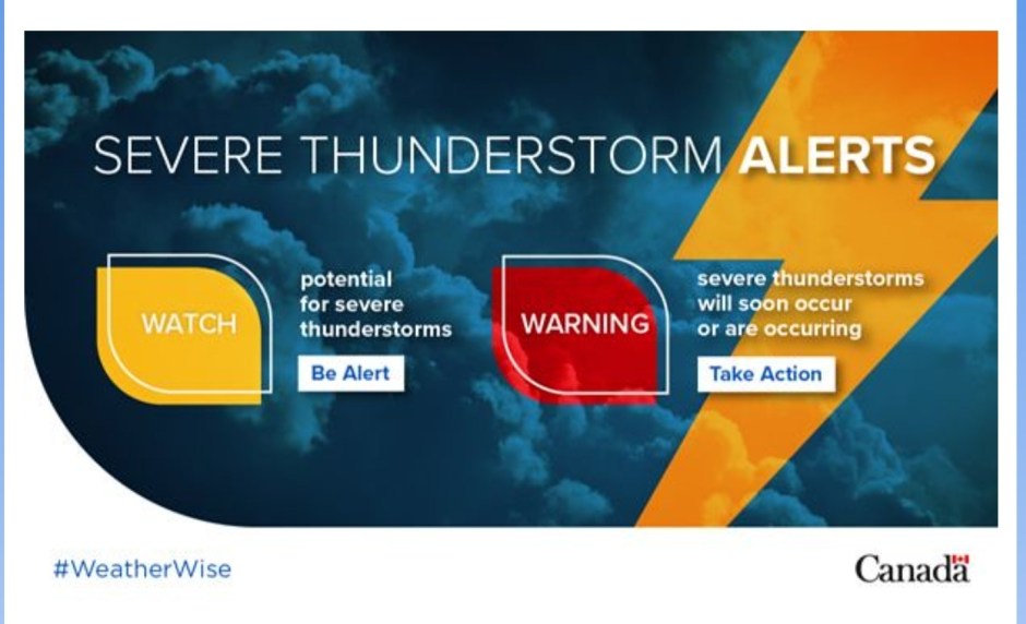
With temperatures rising and skies darkening, it’s important to know how to prepare for summer severe weather. It’s time to brush up on our terminology, and that starts with understanding the difference between a severe thunderstorm watch and a warning.
A watch means that weather conditions are favourable for a storm, which could cause safety concerns around the greater area of where you live, not just for the city or town you reside in. A watch will appear in a yellow banner on most Canadian made weather apps such as The Weather Network and Environment Canada weather app.
Constant daily posts of Severe Storm Watches seems to be redundant these days because of how the public perceives the message, particularly when a thunderstorm doesn’t come to their neighborhood as said by the radio host, or the social media news page.
Posting severe storm warnings however, grabs the attention of the reader far better than posting that severe weather is a possibility for the day. Most Canadians have a weather app on their smartphone to let them know that anyway. The real deal is the warning criteria..
A warning is the most severe alert Environment Canada issues. This means that severe weather is either happening or about to occur, and it’s time to take action to stay safe. A warning will appear in red on most Canadian made weather apps such as The Weather Network and Environment Canada weather app.
When a warning banner appears it will take just a few minutes to show the full extent of the details and the exact location that will see the severe weather. At first, the bulletin will tell the reader that severe weather is approaching and the danger it poses but the exact location isn’t there yet so it is imperative to go back and check again.
Now please keep this in mind..
Just because a warning pops up say for example “Severe Thunderstorm Warning Fort St. John, BC ” that does not mean it is necessarily for the City of Fort St. John. It means the greater area of Fort St. John, including Taylor, Charlie Lake, Montney, Cecil Lake, and the list goes on.
It works this way for all communities in Canada that dish out weather details and stats from their local airports. It is imperative to check the bulletin again shortly thereafter for updates. The severe bulletin is always updated within 2 to 4 minutes of it being issued with further location details and instructions. The bulletin will be continuously updated until the threat is no longer there.
The same goes for storm warnings on the television. It will appear in red on the Weather Network TV channel and again takes 2 to 4 minutes to be updated initially with further instructions.

Don’t let a severe thunderstorm warning catch you off guard! These alerts can also indicate the potential for tornadoes, so it’s important to stay aware and alert to the weather conditions around you.
If conditions are favourable for a tornado to form, Environment Canada will usually issue both a “tornado watch” and a “tornado warning”. A watch means that the conditions are ripe for a tornado, while a warning means that one has been spotted or indicated by radar. Remember, tornadoes can strike with little warning and cause significant damage.
Interested in the criteria Environment Canada uses to issue alerts for different weather hazards? Visit their criteria for weather alerts webpage.
If you see the banner turn green, the threat is over, however, storms may linger but may not be severe in nature.